
Last modified: 2026-02-28 by rick wyatt
Keywords: tuttle | oklahoma | grady county |
Links: FOTW homepage |
search |
disclaimer and copyright |
write us |
mirrors
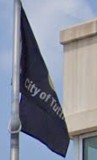
![[Flag of Tuttle, Oklahoma]](../images/u/us-oktut.gif) image by David Sigley, 27 January 2026
image by David Sigley, 27 January 2026
based on photo
See also:
The flag is a black field with the city logo in the center, and the city's name underneath it. This flag was first seen in December 2021 Google Streetview after replacing the previous flag.
Google Streetview of the flag: https://www.google.com/maps/@35.2908028,-97.8157269
David Sigley, 27 January 2026
![[Seal of Tuttle, Oklahoma]](../images/u/us-oktut).gif) image by David Sigley, 27 January 2026
image by David Sigley, 27 January 2026
The seal shows a red ring with the city's name and founding year. Another blue ring is also present which shows a single wheat ear on either side. In the center is a quad-section in gold. The first quad two native American teepees, possibly for the Choctaw people, along with some oil derricks for the oil industry of the region. The second quad shows a monument dedicated to the Silver City Pioneers of the the Chisolm trail. The third quad shows a sign for Silver City, a historic settlement located north of Tuttle and east of Minco. The fourth quad shows the Tuttle depot.
Source: https://www.facebook.com/photo/?fbid=144953276297&set=a.224808893027811
David Sigley, 27 January 2026
![[Logo of Tuttle, Oklahoma]](../images/u/us-oktut-l.gif) image by David Sigley, 27 January 2026
image by David Sigley, 27 January 2026
Source of the logo: https://ilsr.org/article/community-broadband-networks/growing-oklahoma-community-embraces-benefits-of-publicly-owned-fiber-network/
David Sigley, 27 January 2026
I admire the new city flag with its emblem and motto A SMALL COMMUNITY, WELL
CONNECTED. Both seem to refer both to the oil wells that fueled its early growth
and to the modern city-owned optical fiber network.
John Ayer, 28
January 2026
![[Previous flag of Tuttle, Oklahoma]](../images/u/us-oktut-o.gif) image by David Sigley, 27 January 2026
image by David Sigley, 27 January 2026
The former flag is a white field with the city seal in the center, This flag was used until early 2021 according to Google Streetview: https://www.google.com/maps/@35.2908336,-97.8157028
David Sigley, 27 January 2026