
Last modified: 2026-06-06 by rob raeside
Keywords: tacuarembó |
Links: FOTW homepage |
search |
disclaimer and copyright |
write us |
mirrors
The department of Tacuarembó (96,013 inhabitants in 2023) is the largest department of Uruguay and it is part of its northern region. Its capital is Tacuarembó.
Ansina has not adopted any municipal flag it appears, not even an unofficial one. Ansina was created in 2015 through Law N.º 19319 and has its seat in Villa Ansina.
Daniel Rentería, 19 December 2025
![[logo]](../images/u/uy-ta-an).gif) image
by Daniel Rentería, 19 December 2025
image
by Daniel Rentería, 19 December 2025Source: https://www.facebook.com/photo
The Ansina logo is circular and stylized, depicting a sunset over which two birds are seen; at the bottom are waves especially indicating the Tacuarembó River where it is next to. To the side is a tree indicating the vegetation. At the top, Municipio; and at the bottom Villa Ansina; both are in white with a blue glow.
Daniel Rentería, 19 December 2025
![[Caraguatá Municipality Flag]](../images/u/uy-ta-cg.gif) image
by Daniel Rentería, 19 December 2025
image
by Daniel Rentería, 19 December 2025based on photo
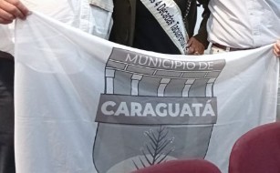
Caraguatá was established on 23 November 2023 through Decree 36/2023. The
initiative for its creation had existed since 2018; during the time of the
initiative, a flag had already been adopted in 2020. Its municipal seat is of
the same name (Villa Caraguatá) or more commonly as Las Toscas.
Its flag
was adopted some time in the second half of 2025 after 11 July 2025, when the
council under mayor Dr. Álvaro Mattos was established; and first seen in a
public photo on 10 October. Although the flag is not really official, it has
effectively replaced the first flag. The current flag is white with the coat of
arms over it.
Current flag photo from
https://www.facebook.com/photo and drawing using logo at
https://www.facebook.com/photo
Daniel Rentería, 19 December 2025
![[Caraguatá Municipality arms]](../images/u/uy-ta-cg).gif) image
by Daniel Rentería, 19 December 2025
image
by Daniel Rentería, 19 December 2025
The coat of arms was first used sometime between the establishment of the
first mayor, Dr. Álvaro Mattos, on 11 July 2025 and sometime in August. The coat
of arms is entirely in white to brown shades. It is a shield with a ribbon in
the center that extends outwards slightly, reading CARAGUATÁ. Above this, five
pillars supporting a roof indicate the government; finally, above this it reads
MUNICIPIO DE (Municipality of).
The lower half of the shield depicts a
caraguatá plant (Bromelia balansae) as its namesake, found in front of the sun.
Under the shield, words are arched to read "EL MÁS GRANDE DE LA PATRIA" (The
Biggest of the Fatherland), alluding to both the Tacuarembó motto (El pago más
grande de la patria; pago roughly meaning "countryland") and the fact Caraguatá
is the biggest Municipality of Uruguay.
Daniel Rentería, 19 December 2025
![[Caraguatá Municipality Flag]](../images/u/uy-ta-cg1.gif) image by
Birk Høj Mortensen, 23 April 2026
image by
Birk Høj Mortensen, 23 April 2026
based on photo
Former logo
![[Caraguatá Municipality arms]](../images/u/uy-ta-cg1).gif) images
by Daniel Rentería, 19 December 2025
images
by Daniel Rentería, 19 December 2025
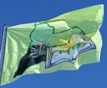
During the time of the initiative for its creation starting in 2018, its
first flag was officially hoisted on 18 September 2020 at 3 PM (though hoisted
for the first time a few days before, likely on 14 September); it was created
through a contest starting in December 2019. This flag also had a more official
status, being used by the temporary local council established by 2024 until the
official municipal government was established on 11 July 2025 under Dr. Álvaro
Mattos. The symbol on the flag was also used as a logo. Unfortunately, I do not
know the designer of the flag.
The first flag depicts, over a light green
field, a map of Tacuarembó outlined in a darker green. Inside of the map is also
a map of a light but darker field of green, over which a caraguatá plant
(Bromelia balansae) grows over the dark soil; representing its name origin
(specifically from the arroyo of the same name derived from the same plant) and
agricultural economy.
To the right side, an open book for wisdom emerges
telling the historic past, over which a green bridge over water is found. Golden
rays emerge from the bridge. This bridge is a reminder that the municipal seat
was known as Paso de las Toscas (a pass), indicating that it was one of the main
spots where wagons could easily pass over the arroyo.
First flag drawing including logo from image at
https://www.facebook.com/photo and flag photo at
https://www.facebook.com/photo
Daniel Rentería, 19 December 2025
Paso de los Toros is the second largest city in Tacuarembó. Though it was
established as a town under the name of Santa Isabel on 17 July 1903, it was
renamed on 20 November 1929 through Law N.� 8.523 and received the status of
villa. From what I can see, Paso de los Toros does not have an official flag.
Daniel Rentería,
20 December 2025
![[arms]](../images/u/uy-ta-pt).gif) image
by Daniel Rentería, 20 December 2025
image
by Daniel Rentería, 20 December 2025
Source:
https://www.facebook.com/photo
The coat of arms was designed by the colonel Raúl Naranja Vaz and created
through a contest, being presented in an Act in 1977.
Description from
https://municipiopasodelostoros.gub.uy/institucional/:
Daniel Rentería, 20 December 2025
![[arms]](../images/u/uy-ta-pt!.gif) image
by Daniel Rentería, 20 December 2025
image
by Daniel Rentería, 20 December 2025
based on photo
at
https://www.facebook.com/photo
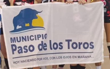
Paso de los Toros does not have an official flag that is known. As a
placeholder especially at sporting events, a white flag with the logo is used
but is not official. Sometimes, local residents use a yellow flag with a logo
(of Liga Isabelina de Fútbol) over it and with
the name PASO DE LOS TOROS; this is only an Isabelina league sporting flag,
however.
Daniel Rentería, 20 December 2025
![[arms]](../images/u/uy-ta-sg.gif) image
by Daniel Rentería, 20 December 2025
image
by Daniel Rentería, 20 December 2025
based on photo
at https://maps.app.goo.gl
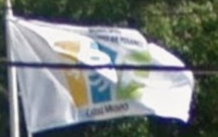
The flag of San Gregorio de Polanco flies in front of the municipal building. It
is white with the logo centered upon it (as seen on Google Maps in 2015).
Specifically, it is a version of the logo which has the text MUNICIPIO and SAN
GREGORIO DE POLANCO above; with the motto Ciudad Museo underneath. It reads this
motto as the Municipality has the first open-air visual arts museum in the
country, established in 1993.
Note: it is unclear if this same version is
still used to this day.
Daniel Rentería, 20 December 2025
![[arms]](../images/u/uy-ta-sg).gif) image
by Daniel Rentería, 20 December 2025
image
by Daniel Rentería, 20 December 2025
Source:
https://municipiosangregorio.com.uy
San Gregorio de Polanco does not have a coat of arms. Instead, it uses a logo. The logo depicts three rectangles with a pointed end, each rectangle not being connected; in order, yellow, blue, and green. Possibly, this represents a building. Each rectangle has an initial of the Municipality (SGP). It is clear that the logo is a representation of the artistic nature of the area, especially in its museums. To the side or at the bottom, often it reads: MUNICIPIO DE SAN GREGORIO DE POLANCO.